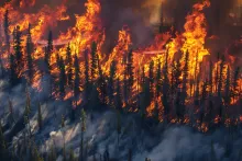
The BRIDGE project was launched in Portugal with the aim of reducing wildfire risk through the direct involvement of local communities. The pilot case is Monchique, in the Algarve, a territory severely affected by the 2018 fires. Here, environmental and social vulnerabilities intersect, such as widespread eucalyptus plantations, land abandonment, and rural depopulation. The project adopts a community-based disaster risk reduction approach, valuing local knowledge and fostering collaboration with institutions and research. A central tool is participatory mapping, which engaged landowners in identifying risk areas, vulnerabilities, and possible prevention measures.
Map
BRIDGE
General Information
Community-based strategies to reduce wildfire risk
The project was created to address the high wildfire risk in Monchique, Portugal, a territory that in 2018 experienced one of the country’s most devastating fires. The area is highly vulnerable due to the extensive presence of flammable eucalyptus plantations, the abandonment and poor management of land, and the depopulation and aging of the rural population. These factors have weakened local prevention and response capacity, making it necessary to develop innovative and participatory risk reduction strategies based on the direct involvement of the community.
Hazard Type
Geographical Scope - Nuts
Geographical Scope
Population Size
Population Density
Needs Addressed
Recurrent and devastating wildfires in Monchique (peaking in 2018) within a highly vulnerable context: extensive eucalyptus plantations and fuel accumulation, land abandonment and fragmented private ownership, inadequate infrastructure (rural roads, water points, power lines), and rural depopulation/aging that weaken territorial management capacity. Existing policies and plans are poorly tailored to local specificities. Hence, a need for an approach that integrates local knowledge and community action to identify risks/vulnerabilities and co-design effective prevention and adaptation measures.
In Monchique, vulnerable groups include older adults, children, people with disabilities, and a share of the migrant population. These groups have specific needs during preparedness and emergencies: assisted evacuation plans and dedicated transport for isolated homes; physical accessibility to water points and escape routes; multi-channel, multilingual alert messages; neighborhood/volunteer networks for rapid check-ins; coordination with social and health services for ongoing post-event support. The approach also provides targeted information sessions (schools, senior centers), community-level vulnerability mapping, and procedures for the prior reporting of special needs.
After the 2017 crises, the country created an Integrated Rural Fire Management System that clarifies roles and responsibilities across the whole cycle prevention, preparedness, response, and recovery. At the strategic level, AGIF leads policy design and coordinates the National Plan for Integrated Rural Fire Management (PNGIFR), which introduces an integrated governance model with measurable targets (e.g., reducing burned area, promoting active land management). For emergency operations, ANEPC issues the annual National Operational Directive No. 2 (DECIR), which defines staffing, resources, and seasonal phases, and coordinates civil protection, fire brigades (bombeiros), and other forces in the field. The forestry and land-use planning components fall to ICNF, which sets the PNDFCI and oversees the Municipal Plans for Forest Defence Against Wildfires (PMDFCI) mandatory tools through which municipalities translate national rules into local actions (prevention, rural road networks, water points, fuel management). Municipalities often working in inter-municipal networks—integrate these outputs into their plans and budgets and implement them together with local civil protection and landowner/forestry associations; when necessary, the country also draws on the EU Civil Protection Mechanism.
Emergency preparedness builds on seasonal planning and local coordination: municipalities update PMDFCI measures before fire season; ANEPC’s annual DECIR sets phased readiness levels, staffing, and stand-by periods. Pre-season actions include fuel-break maintenance (around homes/roads), inspection and repair of rural access, water points and hydrants, and pre-positioning of equipment and patrol routes for high-risk days. Community measures cover targeted briefings in schools/senior centers, multilingual alerts, household self-protection checklists, and assisted-evacuation lists for elderly/disabled residents in isolated homes. Participatory mapping feeds a georeferenced registry of vulnerabilities to refine evacuation routes and safety points. During the season, civil protection, fire services, municipality, and landowner associations hold regular coordination meetings, run joint drills, and activate rapid information protocols; after the season, lessons-learned reviews adjust priorities for the next cycle.
Infrastructure is present but uneven and often undersized for wildfire risk. Rural roads include many narrow, degraded segments: targeted widening, passing bays, and scheduled maintenance are needed to guarantee access for vehicles and safe egress. Water points (tanks, cisterns, hydrants) exist but are sometimes hard to reach or have insufficient pressure: they should be mapped in GIS, signposted on site, protected from heat (buried piping), equipped with backup supply, and checked pre-season. Power lines cross forested areas: right-of-way fuel management and rapid coordination with the grid operator are required for at-risk lines. Radio/cellular coverage is patchy in some valleys: deployable repeaters and interoperability protocols among field forces are advisable. Local biomass facilities are lacking (or too few), limiting the disposal/valorization of removed fuels. Helicopter landing points, lookout posts, and evacuation signage should be standardized. Finally, framework contracts for mowing/thinning, dedicated budgets, and a public, regularly updated registry of access roads, hydrants, reservoirs, and critical issues are needed to guide maintenance and priorities.
Stakeholder engagement (primarily landowners) serves to integrate local and scientific knowledge for wildfire risk reduction, promote social learning and collaborative networks, and strengthen institutional and community adaptive capacities (InnoLab). It also builds a local database recognized by communities, authorities, and researchers to be used alongside “official” datasets to guide plans and policies (e.g., PMDFCI). Landowners are involved because they are directly affected, hold place-based knowledge, and are responsible for managing private forests; through participatory mapping they co-identify risks and vulnerabilities and co-propose priority, feasible measures
- Participatory mapping workshops with landowners (3 sessions): marking homes, commonly used roads, vulnerable groups, risk areas, and priority measures on base maps.
- Innovation Laboratory (InnoLab) as an ongoing space for dialogue, social learning, and sharing among scientific, public, and private actors.
- Map-based focus work (around 1:25,000 Google Earth maps) to stimulate discussion and shared decisions.
- Engagement via local organizations (owners’/environmental associations and the agricultural cooperative) with targeted invitations and co-organized logistics.
- Co-design of measures during workshops (collective debate on risk-reduction interventions).
- Georeferenced data (GIS) collection/management and a technical report to consolidate results for use by local authorities and researchers.
Participants substantially influence both design and implementation. During the mapping workshops, they determine what goes on the agenda (map features, risk areas, vulnerable groups) and where to intervene; discussion around the maps leads to shared proposals for measures and operational priorities, not just one-off reports. The proposals that emerged (e.g., accessibility to water points, monitoring posts, revision of local policies, a biomass plant, a firefighting certificate for landowners) form a package of 7 strategic measures that guide decisions and resources. The outcomes are formalized in a technical report and a GIS database recognized by the municipality/technicians/researchers and used to update plans and policies (e.g., PMDFCI), turning community input into integrated decisions. The InnoLab provides a venue for iterative co-decision: scientific, institutional, and community actors discuss evidence, realign priorities, and build capacity, supporting a locally led and replicable CBDRR process.
The intervention builds capacity and long-term empowerment on multiple levels: it strengthens social learning and collaborative networks through the InnoLab, which provides a stable space for dialogue between communities, technicians, and institutions and develops both social and institutional adaptive capacities (CBDRR); it transfers practical skills via mapping workshops (identifying risks, vulnerable groups, action priorities), turning landowners into co-analysts of the territory and co-deciders of measures; it consolidates a local knowledge base (technical report + GIS database) recognized by communities, authorities, and researchers, enabling decisions to be revisited and updated season after season; it guides action with a package of seven strategic measures (e.g., access to water points, monitoring posts, policy revision, a biomass value chain, a firefighting certificate for landowners), linking participation to operational choices and long-term investments; finally, it provides for scale-up/replication to other at-risk territories, so that locally developed practices and tools become lasting resources for community resilience.
Vulnerable Groups
Governance
Emergency Preparedness
Infrastructure Readiness
Engagement Level
Empowerment Level
Implementation
- Science–community integration (CBDRR): an action-research approach that blends local knowledge and scientific evidence to reduce wildfire risk.
- Innovation Laboratory (InnoLab): a standing forum for dialogue and social learning among scientific, institutional, and community actors to strengthen adaptive capacity and collaborative networks.
- Structured participatory mapping (5 steps): three workshops with landowners to identify homes/roads, vulnerable groups, risk areas, and priority measures on 1:25,000 Google Earth base maps.
- Local georeferenced database + technical report: bottom-up VGI data (with quality caveats) recognized by communities, authorities, and researchers to inform plans/policies (e.g., PMDFCI).
- Co-defined package of 7 strategic measures: from improving access to water points and installing monitoring posts to policy revision, a biomass value chain, and a “firefighting certificate” for landowners.
- Targeted engagement via local organizations: landowner/environmental associations and the agricultural cooperative mobilize diverse publics and lend legitimacy.
- Focus on vulnerable groups in mapping: older adults, children, and people with special needs are highlighted to plan evacuations and priorities.
- Scalability/replicability: tools and outcomes are shared to extend the approach to other at-risk territories in Portugal and beyond.
Portuguese, English
- Instituto Superior Técnico (University of Lisbon) - coordinator
- Laboratório Nacional de Engenharia Civil (LNEC)
- University of Algarve (UALg)
The consortium combines long-standing DRM expertise in research, planning, and operations:
- Instituto Superior Técnico (IST) leads applied research on wildfire risk reduction and participatory methods (CBDRR), coordinating the BRIDGE project and the InnoLab process.
- LNEC (National Civil Engineering Laboratory) contributes technical risk analysis, planning support, and integration with civil-protection practices.
- University of Algarve (UALg) brings territorial/agro-environmental competence (MED institute) and GIS capacity for the georeferenced database used to inform municipal plans.
- Local land and forest owners engaged in the mapping workshops.
- Local associations: Aspaflobal (forestry producers), Coopachique (agricultural cooperative), A Nossa Terra (environmental), Monchique Alerta
- Municipality of Monchique / Municipal Council (involved for outreach and liaising with other landowners).
- Innovation Laboratory (InnoLab) as a forum bringing together scientific, public, and private actors for coordination.
- Universities/research centers: Instituto Superior Técnico (IST, coordinator), LNEC, University of Algarve (UALg/MED).
- Setup and governance: launch the Innovation Lab (InnoLab), define objectives, stakeholders, and ground rules.
- Materials preparation: build the 1:25,000 base map (Google Earth) with references only (boundaries, roads, centers); select venues and schedule.
- Target mobilization: send targeted invitations via local organizations (Aspaflobal, Coopachique, A Nossa Terra, Monchique Alerta) and the Municipality.
- Run workshops (3 sessions) with a 5-step procedure: (a) map orientation; (b) locate homes/roads/forest areas; (c) map vulnerable groups, risk areas, and factors; (d) co-design measures; (e) collective validation.
- Consolidate outputs: digitize workshop products, draft the technical report, and create the GIS database (locations, vulnerabilities, access, risks, proposed measures).
- Prioritization: agree on a shared package of strategic measures from the debates to guide decisions and resources.
- Policy integration: make the report and GIS available to local authorities and researchers to update/steer plans and instruments (e.g., PMDFCI).
- Learning cycle: use the InnoLab continuously to track results, re-prioritize, broaden engagement, and support replication in other territories.
- Human resources: workshop facilitators and mediators; GIS technicians for digitization and database creation; researchers/InnoLab conveners; municipal/civil-protection liaisons; local association focal points for landowner mobilization.
- Workshop materials and logistics: large-format base maps (1:25,000 from Google Earth) with references only, markers, sticky labels, data sheets; venues in parishes, schedule, and targeted invitations.
- Technical infrastructure: GIS software and storage for the georeferenced database, tools for scanning/digitizing outputs, PCs and a projector for feedback sessions; a shared repository between municipality and research teams.
- Organizational engagement: collaboration with Aspaflobal, Coopachique, A Nossa Terra, and Monchique Alerta for invitations, logistics, and process legitimacy.
- Deliverables: a technical report summarizing outcomes and a GIS with locations, access, vulnerabilities, risk areas, and proposed measures, to be made available to authorities and practitioners.
- Financial resources: budget for meetings (venue rental, map printing, materials, travel reimbursements), staff time (facilitation, GIS), and follow-up/policy-integration activities. (Example: BRIDGE is funded by FCT).
- Data agreements and safeguards: protocols for data sharing among municipality/research/associations; attention to VGI data quality/credibility and protection of sensitive information (vulnerable households).
- Policy integration: access to existing plans (e.g., PMDFCI) to align and update measures and priorities with process outcomes.
- Setup and governance: launch the InnoLab, define objectives/stakeholders/rules, and prepare materials (1:25,000 base maps).
- Engagement and data collection (pre-season): three participatory mapping workshops with landowners (March–April 2022) to identify homes/roads, vulnerable groups, risk areas, and measures.
- Processing: digitize workshop outputs, draft the technical report, and create the GIS database.
- Policy integration: provide the report/GIS to authorities to update local instruments (e.g., PMDFCI) and operational priorities.
- Learning and monitoring cycle: InnoLab active throughout Task 2 (approx. March 2022–February 2023) for pre-/post-season reviews and adjustments.
- Capitalization/replication (Task 3): share methods and results to extend the approach to other territories.
Experience of the Implementing Organisation in DRM
Target Audience
Resources Required
Timeframe & Phases
Participation Results
- Fragmented land ownership, depopulation, and abandonment (eucalyptus, fuel load) → participatory mapping to locate risks/vulnerabilities and co-define operational priorities (access, fuel management), resulting in a shared package of seven strategic measures.
- Inadequate rural roads and water points (accessibility, pressure, heat exposure) → georeferenced inventory and interventions: widening/passing bays, scheduled maintenance, signage, buried piping, and pre-season checks.
- Risks from power lines in forested areas → coordination with grid operators and right-of-way fuel management as a participant-proposed priority.
- Credibility/quality issues with VGI data and scale/georeferencing problems → transparency about limits, integration of workshop results into a GIS database and technical report to be used alongside “official” datasets.
- Policies/plans poorly tailored to local specificities → use of the InnoLab as a neutral co-decision space and integration of outcomes into PMDFCI and municipal planning.
- Economic hurdles in fuel removal and lack of a value chain → proposal for a biomass plant and bonded deposits for post-harvest restoration by companies.
- Vulnerable populations and foreign residents (isolated homes, special needs, language) → dedicated mapping of vulnerable groups and engagement via local associations for targeted information and assisted evacuation plans.
- Fire spread favored by topography/winds (funneling effect) → proposal for monitoring/lookout posts at strategic points as part of community measures.
- Accessibility to water points: inventory and condition checks; improve access roads, bury piping to prevent melting during fires, and ensure adequate pressure/refill.
- Rural road network: prioritize maintenance/widening on the most-used routes for evacuation and vehicle access; signage and passing bays for safety.
- Power lines in forested areas: manage rights-of-way and coordinate with the grid operator to reduce ignitions and enable rapid intervention.
- Monitoring/lookout posts at strategic points along the Serra for timely alerts and support to initial attack.
- Biomass value chain: local plant and resolution of administrative constraints for mulching equipment; allows valorization of removed fuels and reduces accumulation.
- Revision of territorial plans and policies (PMDFCI and other instruments) to better fit local specificities and landowner expectations.
- Firefighting certification for landowners: attesting conditions/resources for home defense, with the right to remain on-site during the event if safe.
- Mapping of vulnerable groups (older adults, children, special needs) with assisted-evacuation plans and dedicated safe points.
Risk & Mitigation Plan
Scalability and Sustainability
Information not available
The method (mapping workshops + InnoLab + GIS) is designed to be replicated in other wildfire-prone territories in Portugal and elsewhere; it requires adaptation to local contexts and actors while maintaining the CBDRR focus.
Structured use of GIS and base maps (1:25,000 Google Earth), a georeferenced database, and a technical report; not “smart/adaptive” in the IoT/AI sense, but mature technology supporting decision-making.
Information not available
Information not available
- Participatory mapping improves the quality and acceptance of decisions.
- Involving local associations accelerates trust, turnout, and legitimacy.
- The micro scale (actual homes, roads, water points) makes measures actionable.
- Community-generated data must be integrated with “official” datasets and field checks.
- Simple visualizations (printed maps, clear symbols) facilitate discussion.
- Early integration into municipal plans (e.g., PMDFCI) prevents results from staying on paper.
- The InnoLab supports continuous learning and capacity transfer.
- Basic infrastructure priorities (access roads, hydrants, signage) are decisive on critical days.
- Planning must include vulnerable groups with dedicated procedures.
- Replicability requires a minimal toolkit (method + GIS) and agreements on governance and data.