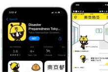
This app is designed with the concepts of "play," "learn," and "use," allowing users to acquire disaster preparedness knowledge in an engaging way. In addition to interactive features, it provides booklets, prevention maps, and other vital resources for use during emergencies. The inclusion of "Kids Mode" and "Senior Mode" ensures accessibility and usability for a wide range of users.
Map
Disaster Preparedness Tokyo App
General Information
The app delivers disaster preparedness information tailored to the user's profile.
Tokyo Metropolis is Japan’s capital and a prefecture-level unit with a unique “Metropolis” status. It includes the 23 special wards, western suburban cities, towns, villages, and remote islands. With a population of around 14 million, Tokyo is one of the world’s largest metropolitan economies and a major hub for finance, commerce, and culture. Tokyo faces significant natural hazards including earthquakes, typhoons, and flooding, compounded by high population density and complex urban infrastructure. The Tokyo Metropolitan Government manages disaster preparedness through comprehensive planning, public education, and technological tools.
Hazard Type
Geographical Scope - Nuts
Geographical Scope
Population Size
Population Density
Needs Addressed
The App addresses challenges such as limited access to disaster information, difficulties in planning for emergencies, and risks of poor decision-making during disasters. It provides users with organized guidance on local hazards, evacuation routes, emergency facilities, and safety procedures, helping to reduce panic and increase readiness.
The App specifically addresses vulnerable groups such as children and the elderly through its “Kids Mode” and “Senior Mode”. Additionally, features like multi-language help cards support non-Japanese speakers, further extending accessibility to people who may face language barriers during emergencies.
Emergency management in Tokyo is characterized by multistakeholder governance, involving collaboration among public authorities, private sector actors, research institutions, and the community. The Tokyo Metropolitan Government coordinates disaster management policies and services across the city. Fire and police departments, disaster prevention centers, research centers, community organizations, and volunteers handle rescue, training, and local preparedness. Companies maintain essential services, while residents participate in drills and follow preparedness guidance.
Tokyo’s emergency preparedness is recognized internationally as a model for urban disaster management. The city’s emergency preparedness is based on comprehensive planning, strict building codes, early-warning systems, public education, and integration of technology.
Tokyo’s infrastructure readiness is very high, with earthquake-resistant buildings, robust transportation networks, reliable utilities, and integrated disaster management systems. Evacuation routes, shelters, and emergency logistics are well planned.
The Disaster Preparedness Tokyo App engages users with the purpose of increasing awareness, knowledge, and proactive behavior regarding disaster preparedness. The engagement aims to educate individuals and households, encourage them to plan and practice emergency measures, and strengthen community-level coordination.
The methods of engagement include interactive quizzes, checklists, gamified features and practical tools such as disaster preparedness booklets, personalized evacuation routes, and maps of hazard zones. The app also uses simulations, push notifications, safety confirmation tools, and group communication features to facilitate active participation. Offline access to resources and multi-language support further ensures that users can engage continuously and effectively, regardless of circumstances.
Users influence their personal and family preparedness by making informed decisions based on the App’s guidance, though it does not directly impact official disaster management policies.
The App strengthens long-term resilience and enhances decision-making capacities in disaster situation, by promoting habitual preparedness, offering real-time hazard information, and facilitating communication among families and communities.
Vulnerable Groups
Governance
Emergency Preparedness
Infrastructure Readiness
Engagement Level
Empowerment Level
Implementation
The App is innovative for combining interactive learning, personalized planning, and real-time disaster information in one platform. Its gamified features, checklists, offline access, and age-specific modes make preparedness engaging and accessible. Integration with official Tokyo Metropolitan Government resources ensures reliable guidance, while safety confirmation and group communication tools support effective coordination during emergencies, strengthening both individual and community resilience.
Japanese, English, Chinese (traditional and simplified), and Korean.
Tokyo Metropolitan Government.
Tokyo Metropolitan Government's DRM experience is characterized by a comprehensive approach that combines infrastructure development, public education, technological innovation, and policy implementation
Tokyo Metropolitan Government.
The steps involved in the App’s implementation have not been publicly disclosed.
The App’s implementation relied on three main resources: institutional support from government and disaster authorities for the development of educational contents such as emergency management guides, technical resources for the development of the app and its features like GIS-based risk mapping, and public financial resources for development, maintenance, and updates.
The App’s timeframe and implementation phases have not been publicly disclosed.
Experience of the Implementing Organisation in DRM
Target Audience
Resources Required
Timeframe & Phases
Participation Results
Information on lessons learned from the App’s development and implementation has not been publicly disclosed.
Information on the challenges faced during implementation and the adaptive strategies used has not been publicly disclosed.
Details on the app’s risk assessment and mitigation plan have not been publicly disclosed.
Risk & Mitigation Plan
Scalability and Sustainability
There is not a publicly detailed breakdown of the app’s maintenance. However, since the App is managed by the Tokyo Metropolitan Government, it provides reliable information and official guidance. Disaster details, checklists, maps, and contacts are updated as needed, while seasonal or event-specific content is added to keep the app current and practical.
The App’s core functions, such as guides, checklists and interactive tools, could effectively support preparedness in different cities or countries. However, an appropriate customization to local conditions is required. For instance, hazard information, emergency facilities, and official data would need to be tailored to reflect the risks, infrastructure, and disaster management systems of each city.
The App goes beyond delivering static information by actively engaging users through quizzes, gamified elements, and checklists, and tailoring content for different age groups, which demonstrates a smart and adaptive design that meets diverse needs.
The direct costs of implementing the app have not been publicly disclosed.
The operational costs of implementing the app have not been publicly disclosed.
Information on lessons learned from the app’s development and implementation has not been publicly disclosed.